
The Upper Ray Meadows - Chloe Bradford
100 Miles Wilder
Pioneering sustainable living and nature's recovery
Nature should not be treated as a constraint on growth in the Oxford–Cambridge corridor, it is essential infrastructure underpinning health, climate resilience and long-term prosperity. Delivering successful growth in the region will require more than housing, transport and investment. It will depend on the health of the natural systems that regulate water, store carbon, cool urban environments, support biodiversity and sustain the wellbeing of communities.
Globally, financial flows still overwhelmingly favour environmental degradation, with around thirty times more investment going into activities that damage nature than into protecting or restoring it (UNEP State of Finance for Nature). At the same time, the benefits of nature-rich environments are becoming increasingly clear. Evidence commissioned by The Wildlife Trusts shows that scaling nature-based health programmes could improve wellbeing for more than one million people while saving the NHS approximately £635 million annually. Nature-rich landscapes therefore deliver tangible economic value by supporting public health, reducing long-term service costs and increasing resilience to climate impacts.
Importantly, the policy architecture to deliver this approach already exists. Biodiversity Net Gain (BNG) and emerging Local Nature Recovery Strategies (LNRS) provide a framework for restoring habitats and reconnecting landscapes at scale while guiding development to the most appropriate locations. When combined with strategic landscape initiatives, including the ambition to create a new national forest within the Oxford-Cambridge corridor, these mechanisms could embed nature recovery and climate resilience directly within the region’s growth model.
Embedding whole-life environmental performance within planning and development would ensure that new infrastructure, homes and communities strengthen the natural systems that support them.
By considering carbon, biodiversity, water systems, soil health, climate adaptation and human wellbeing across the lifetime of development, the corridor can deliver growth that supports both economic productivity and environmental recovery.
The Oxford-Cambridge corridor therefore has an opportunity to demonstrate a new model of growth: one where nature recovery, climate resilience and economic development are designed together, creating healthier communities, more resilient landscapes and a stronger long-term foundation for prosperity.
The challenge for the Oxford-Cambridge corridor is not whether nature can fit around growth, but whether growth can be designed to restore the natural and climate systems on which our future depends.
Our vision map
This is our vision for helping nature and planning for people, from Oxford to Cambridge. The map highlights the areas of high value for nature and the living networks for wildlife and people. Click the two images below to see a larger version, and scroll down to learn more about the process of creating our vision.

Living networks for wildlife

The wilder network is a big, bold plan to protect the wildest places, connect them together and increase the overall area available to wildlife, creating a living legacy for generations to come.
It is a pioneering vision to establish a network where nature can recover and wildlife can thrive.

The natural blue and green network connects people to nature, encouraging people to move sustainably by providing access to settlements and wild areas along new and enhanced pedestrian, cycle and boating connections.
Natural corridors allow wildlife to move and migrate freely across the region, linking natural habitats along vibrant green corridors and restored blue waterways.

A concept for a better, more permeable cycle network, strengthening the existing national routes with a ‘green grid’ of new walking and cycling paths, allowing people to navigate the landscape and encouraging sustainable, slow movement.

The east-west rail is a major opportunity to change the way people move across the region, as the railway network expands away from the London-centric model. Consideration of sustainable transport options will be important in informing the most sustainable locations for development.
The need for a new approach
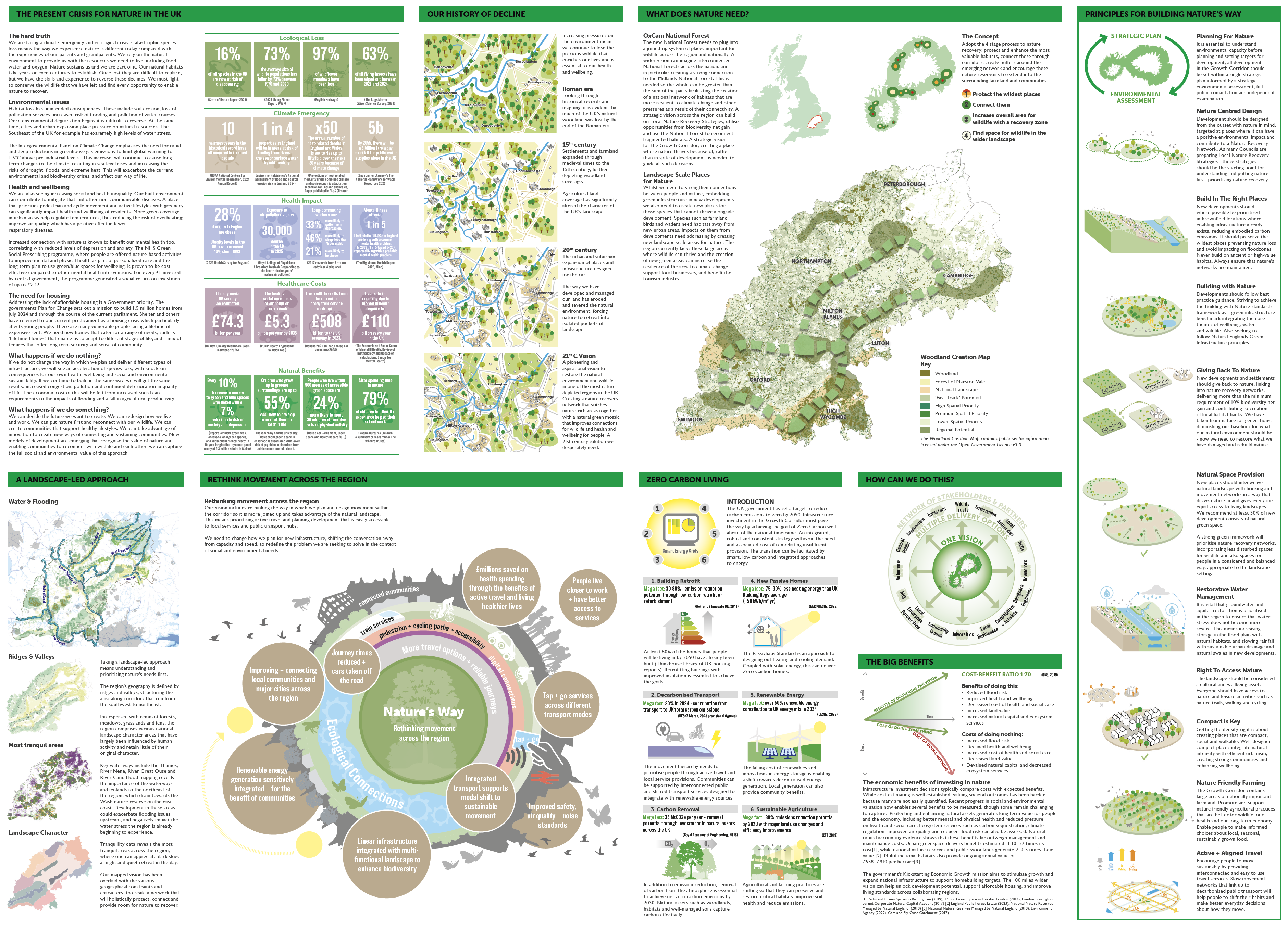
The present crisis for nature in the UK
The hard truth
We are facing a climate emergency and ecological crisis. Catastrophic species loss means the way we experience nature is different today compared with the experiences of our parents and grandparents. We rely on the natural environment to provide us with the resources we need to live, including food, water and oxygen. Nature sustains us and we are part of it. Our natural habitats take years or even centuries to establish. Once lost they are difficult to replace, but we have the skills and experience to reverse these declines. We must fight to conserve the wildlife that we have left and find every opportunity to enable nature to recover.


The need for housing
Addressing the lack of affordable housing is a government priority. The government's Plan for Change sets out a mission to build 1.5 million homes from July 2024 and through the course of the current parliament. Shelter and others have referred to our current predicament as a housing crisis which particularly affects young people. There are many vulnerable people facing a lifetime of expensive rent. We need new homes that cater for a range of needs, such as ‘Lifetime Homes’, that enable us to adapt to different stages of life, and a mix of tenures that offer long-term security and a sense of community.

A landscape led approach
Taking a landscape-led approach means understanding and prioritising nature’s needs first.

Ridges and valleys
The region’s geography is defined by ridges and valleys, structuring the area along corridors that run from the southwest to northeast.

Landscape character
Interspersed with remnant forests, meadows, grasslands and fens, the region comprises various national landscape character areas that have largely been influenced by human activity and retain little of their original character.

Water and flooding
Key waterways include the Thames, River Nene, River Great Ouse and River Cam. Flood mapping reveals the importance of the waterways and fenlands to the northeast of the region, which drain towards the Wash nature reserve on the east coast. Development in these areas could exacerbate flooding issues upstream, and negatively impact the water stress the region is already beginning to experience.

Most tranquil places
Tranquillity data reveals the most tranquil areas across the region, where one can appreciate dark skies at night and quiet retreat in the day.
Rethink movement across the region

Rethinking movement across the region
Our vision includes rethinking the way in which we plan and design movement within the corridor so it is more joined up and takes advantage of the natural landscape. This means prioritising active travel and planning development that is easily accessible to local services.
We need to change how we plan for new infrastructure, shifting the conversation away from capacity and speed, to redefine the problem we are seeking to solve in the context of social and environmental needs.
Zero carbon living

Introduction
The UK government has a legally binding commitment to reduce carbon emissions to zero by 2050. Infrastructure investment in the OxCam Growth Corridor must pave the way by achieving the goal of Zero Carbon by 2030, well ahead of the national timeframe. An integrated, robust and consistent strategy will avoid the need and associated cost of remediating insufficient provision. The transition can be facilitated by smart, low carbon and integrated approaches to energy.

Renewable energy
Mega fact: over 50% renewable energy contribution to UK energy mix in 2024 (DESNZ, 2025)
The falling cost of renewables and innovations in energy storage is enabling a shift towards decentralised energy generation. Local generation can also provide community benefits.

Decarbonised Transport
Mega fact: 30% in 2024 - contribution from transport to UK total carbon emissions (DESNZ March, 2025 provisional figures)
The movement hierarchy needs to prioritise people through active travel and local service provisions. Communities can be supported by interconnected public and shared transport services designed to integrate with renewable energy sources.

Carbon Removal
Mega fact: 35MtCO2e per year – removal potential through investment in natural assets across the UK (Royal Academy of Engineering, 2018)
In addition to emission reduction, removal of carbon from the atmosphere is essential to achieve net zero carbon emissions by 2030. Natural assets such as woodlands, habitats and well-managed soils capture carbon effectively.

New Passive Homes
Mega fact: 75-90% less heating energy than UK Building Regs average (~50 kWh/m2.yr). (BEIS/DESNZ, 2025)
The Passive House Standard is an approach to designing out heating and cooling demand. Coupled with solar energy, this can deliver Zero Carbon homes.

Building Retrofit
Mega fact: 30-80% - emission reduction potential through low-carbon retrofit or refurbishment (Retrofit & Innovate UK,2014)
Some 80% of housing stock that will be needed by 2030 already exists. Retrofitting buildings with improved insulation is essential to achieve goals.

Sustainable Agriculture
Mega fact: 80% emissions reduction potential by 2030 with major land use changes and efficiency improvements (CTI, 2019)
Agricultural and farming practices are shifting so that they can preserve and restore critical habitats, improve soil health and reduce emissions.
How can we do this?

The big benefits

Principles for building nature's way

Planning for nature
It is essential to understand environmental capacity before planning and setting targets for development; all development in the Arc should be set within a single strategic plan informed by a strategic environmental assessment, full public consultation and independent examination.

Nature centred design
Development should be designed from the outset with nature in mind, targeted at places where it can have a positive environmental impact and contribute to a Nature Recovery Network.

Build in the right places
Building in the right places goes beyond aligning strategic land for housing with transport infrastructure, it should preserve the wildest places and avoid impacting on precious core sites and floodzones. Never build on ancient or high-value habitat. Always ensure that nature’s corridors and networks are maintained.

Restorative water management
It is vital that groundwater and aquifer restoration is prioritised in the region to ensure that water stress does not become more severe. This means increasing storage in the flood plain with natural habitats, and slowing rainfall with sustainable urban drainage and natural swales in new development areas.

Giving back to nature
New development and settlements should give back to nature and deliver a net gain for wildlife. This could include funding through a Wildlife Infrastructure Levy or habitat creation schemes to capture carbon at a strategic level.

Natural space provision
Access to nature should be a human right. New places should interweave natural landscape with housing and movement networks in a way that draws nature in and gives everyone equal access to living landscapes. We recommend at least 50% of new development is comprised of natural green space.

Right to access nature
The landscape should be considered a cultural asset. Everyone should have access to nature and leisure activities such as nature trails, walking and cycling.

Compact is key
Getting the density right is about creating places that are compact, social and walkable. Well-designed compact places integrate natural intensity with efficient urbanism, creating strong communities and enhancing wellbeing.

Nature friendly farming
The Arc contains large areas of nationally important farmland. Promote and support nature friendly agricultural practices that are better for wildlife, our health and our long-term economy. Enable people to make informed choices about local, seasonal, sustainably grown food.

Active and aligned travel
Encourage people to move sustainably by providing interconnected and easy to use travel services. Slow movement networks that link up to decarbonised public transport will help people to shift their habits and make better everyday decisions about how they move.